Pagina 3 di 47
Re: irruzione gelida di fine febbraio 2018 mappe commenti
Inviato: dom feb 18, 2018 11:23 pm
da whitesnow12
non molla gfs...
Re: irruzione gelida di fine febbraio 2018 mappe commenti
Inviato: dom feb 18, 2018 11:25 pm
da lupacchiottoirpino
Tanto bello reading, colata perfetta..
Re: irruzione gelida di fine febbraio 2018 mappe commenti
Inviato: dom feb 18, 2018 11:31 pm
da Dany Bononia
Il 18z è pro Nord, avanti il prossimo....

Re: irruzione gelida di fine febbraio 2018 mappe commenti
Inviato: dom feb 18, 2018 11:44 pm
da lupacchiottoirpino
Farlocco fortunatamente
Re: irruzione gelida di fine febbraio 2018 mappe commenti
Inviato: lun feb 19, 2018 12:28 am
da frankietorino
glass1973 ha scritto: ↑dom feb 18, 2018 11:43 pm
mio dio

Ahahahah +20 di differenza in alcune zone
Bere meno
Re: irruzione gelida di fine febbraio 2018 mappe commenti
Inviato: lun feb 19, 2018 6:56 am
da MarcoSarto
Tutto confermato, si allinea anche ukmo
Re: irruzione gelida di fine febbraio 2018 mappe commenti
Inviato: lun feb 19, 2018 8:03 am
da snowrevenge!
Model Diagnostic Discussion
NWS Weather Prediction Center College Park MD
131 PM EST Sun Feb 18 2018
Valid Feb 18/1200 UTC thru Feb 22/0000 UTC
...See NOUS42 KWNO (ADMNFD) for status of the upper air ingest...
...12Z Model Evaluation with Final Preferences/Confidence...
~~~~~~~~~~~~~~~~~~~~~~~~~~~~~~~~~~~~~~~~~~~~~~~~~~~
...Amplified Western US Trough Gradually Building Into the Central
US With Several Shortwaves Rounding the Trough...
...Active Front on Leading Edge of the Trough and Lee Surface
Cyclone, With Additional Weak Cyclogenesis in the Great Lakes...
~~~~~~~~~~~~~~~~~~~~~~~~~~~~~~~~~~~~~~~~~~~~~~~~~~~
Preference: Blend of 12Z ECMWF, CMC, UKMET
Confidence: Average
---18Z UPDATE---
The 12Z runs of the ECMWF, CMC, and UKMET show fairly good
continuity overall with their previous runs, and maintain the idea
of a faster surface low in the Great Lakes, and a slightly faster
southeast progression of the cold front across the central US.
Given that this aligns with the preliminary reasoning, and has
good ensemble support, the preference remains the same.
---PREV. DISCUSSION---
On the synoptic scale, models are generally in good agreement on
the overall position and structure of the large trough that will
be situated over the western half of the contiguous United States,
particularly through Tuesday. Therefore, they are all generally
showing the same basic scenario with slightly different placement
of sensible weather impacts -- emanating from small differences in
timing of shortwaves or mesoscale details.
The 12Z NAM is very similar to the other available models in its
strength of both the trough, and the large mid-upper level
anticyclone positioned just off the Southeast Atlantic coast. It
does show the trough shifted slightly out of phase with the other
models, with the trough axis by 21/00Z about 250km to the west.
This also leads to slightly higher heights across the central U.S.
(where much of the precipitation impacts will be). This bias does
appear to affect its progression of the axis of heaviest QPF, and
thus the preference is to not incorporate the NAM for this system.
Looking at the global models, one more notable difference is
between the 12Z GFS and the 00Z runs of the other global models
(CMC, UKMET, ECMWF). The GFS is slower in ejecting a shortwave and
associated sheared lobe of vorticity to the northeast across the
Plains on Tuesday, and this results in a surface low that is about
6 hours slower than the other models. This affects the eastward
progression of the northern extent of the surface front, and thus
may affect precipitation patterns and other sensible weather
elements. Given a lack of substantial support among GEFS/ECMWF
ensemble clusters for this slower scenario, the preference is to
lean toward the CMC, UKMET, and ECMWF.
...Shortwave Dropping South Along West Coast of North America from
Monday Night into Wednesday...
...Associated Weak Surface Low Just Offshore...
~~~~~~~~~~~~~~~~~~~~~~~~~~~~~~~~~~~~~~~~~~~~~~~~~~~
Preference: Blend of 12Z ECMWF, CMC, UKMET
Confidence: Average
---18Z UPDATE---
The 12Z UKMET did trend to a slightly more amplified trough as it
passes near the OR/CA coastline, and a slightly deeper surface
low. However, the ECMWF and CMC remained relatively consistent,
and the GFS continues to be the most amplified scenario.
Therefore, the preference will remain the same, despite the small
changes on the UKMET.
---PREV. DISCUSSION---
A low-amplitude shortwave dropping south along the West Coast is
forecast to amplify slightly as it passes by the coasts of Oregon
and California. The 12Z GFS (and secondarily the 12Z NAM) is the
most amplified with the trough, and thus produces the strongest
surface low just offshore. This also tends to focus the
precipitation more offshore relative to the other global models,
which show some light precipitation extending inland. The
preference is to lean toward the lower amplitude solutions which
at the moment have better ensemble support. However, with a
southward digging wave, a future trend toward the GFS solution
could not be ruled out.
Re: irruzione gelida di fine febbraio 2018 mappe commenti
Inviato: lun feb 19, 2018 8:30 am
da Davide
Gfs sballato
Re: irruzione gelida di fine febbraio 2018 mappe commenti
Inviato: lun feb 19, 2018 9:15 am
da Aleparma
Ecmwf luce
Re: irruzione gelida di fine febbraio 2018 mappe commenti
Inviato: lun feb 19, 2018 9:19 am
da franco feltre
arriva arriva
Re: irruzione gelida di fine febbraio 2018 mappe commenti
Inviato: lun feb 19, 2018 10:01 am
da Dany Bononia
Re: irruzione gelida di fine febbraio 2018 mappe commenti
Inviato: lun feb 19, 2018 10:05 am
da matteo91
penso che fino a giovedi vedremo continui sposamenti. Ricordiamoci che qua si tratta di aria siberiana, quindi di difficile interpretazione da parte die modelli. Speriamo bene

Re: irruzione gelida di fine febbraio 2018 mappe commenti
Inviato: lun feb 19, 2018 10:06 am
da accul
glass1973 ha scritto: ↑dom feb 18, 2018 10:10 pm
questi erano i spaghi del 2012
migliori di quelli di oggi

Questa in arrivo è pellicolare pura, quella del 2012 non gli lega le scarpe
Re: irruzione gelida di fine febbraio 2018 mappe commenti
Inviato: lun feb 19, 2018 10:06 am
da Davide
Re: irruzione gelida di fine febbraio 2018 mappe commenti
Inviato: lun feb 19, 2018 10:08 am
da Dany Bononia
Re: irruzione gelida di fine febbraio 2018 mappe commenti
Inviato: lun feb 19, 2018 10:13 am
da meteocarnate
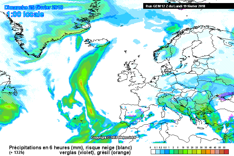
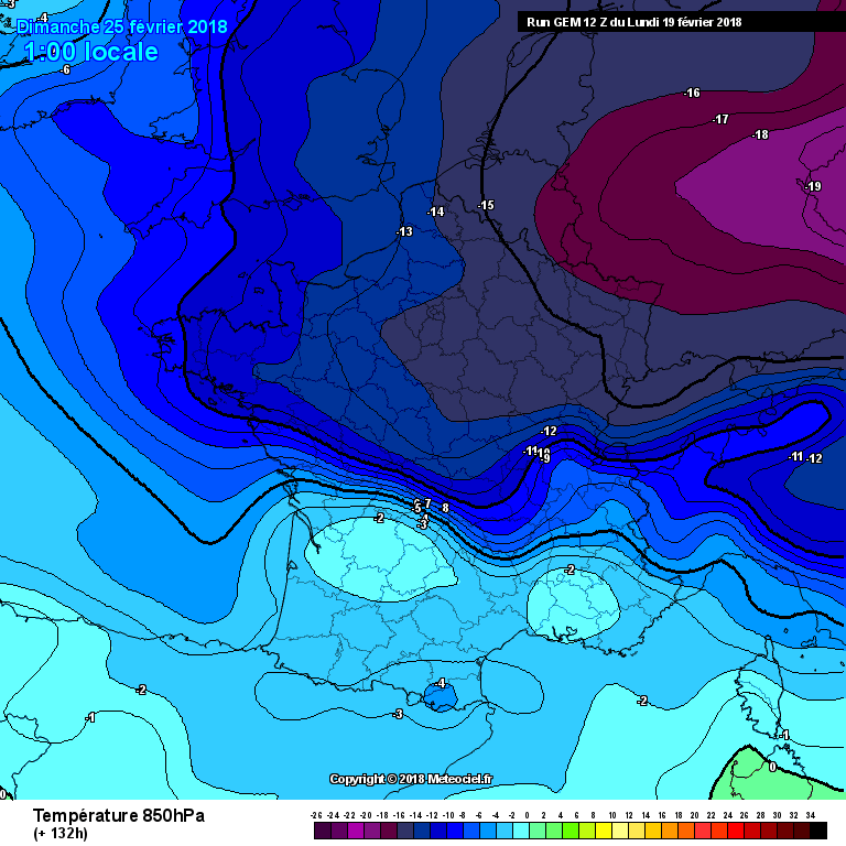
Guardate in ECMWF da dove arriva l'aria Gelida....impressionante. Manca ancora molto ma i ECMWF è stabile da giorni. GFS balla , ma esce 4 volte al giorno. Un commento su GEM....forse il primo a leggere la situazione e a riproporla.
Giusto per identificare il tipo di massa....il 27 Febbraio per ECMWF la massima qui sarebbe -4° con DP -25°!!!!!!!!!!!!!!!!
Re: irruzione gelida di fine febbraio 2018 mappe commenti
Inviato: lun feb 19, 2018 1:11 pm
da Davide
Re: irruzione gelida di fine febbraio 2018 mappe commenti
Inviato: lun feb 19, 2018 1:12 pm
da enzog
meteocarnate ha scritto: ↑lun feb 19, 2018 10:13 am
Guardate in ECMWF da dove arriva l'aria Gelida....impressionante. Manca ancora molto ma i ECMWF è stabile da giorni. GFS balla , ma esce 4 volte al giorno. Un commento su GEM....forse il primo a leggere la situazione e a riproporla.
Giusto per identificare il tipo di massa....il 27 Febbraio per ECMWF la massima qui sarebbe -4° con DP -25°!!!!!!!!!!!!!!!!
GEM, sempre stato number one per l'antizonalità.
Re: irruzione gelida di fine febbraio 2018 mappe commenti
Inviato: lun feb 19, 2018 3:14 pm
da TURCHIA
Egli Cold Turkey
Re: irruzione gelida di fine febbraio 2018 mappe commenti
Inviato: lun feb 19, 2018 3:18 pm
da Mindy
DavideBassano ha scritto: ↑lun feb 19, 2018 1:11 pm
Nella giornata di venerdì la situazione non subirà variazioni di rilievo. Il contesto termico sarà invernale in quota e molto fresco nelle valli. Nei giorni successivi l’ipotesi di una discesa di aria artica sul Nord Italia sembra sempre più plausibile (Splitting (scissione) del vortice polare).
Arpav

Bella lì
Re: irruzione gelida di fine febbraio 2018 mappe commenti
Inviato: lun feb 19, 2018 3:25 pm
da TURCHIA
TÜRKİYE
Re: irruzione gelida di fine febbraio 2018 mappe commenti
Inviato: lun feb 19, 2018 3:26 pm
da TURCHIA
TURKEY

Re: irruzione gelida di fine febbraio 2018 mappe commenti
Inviato: lun feb 19, 2018 3:27 pm
da TURCHIA
Re: irruzione gelida di fine febbraio 2018 mappe commenti
Inviato: lun feb 19, 2018 3:53 pm
da Dany Bononia
Mamma li turchi....

Re: irruzione gelida di fine febbraio 2018 mappe commenti
Inviato: lun feb 19, 2018 4:15 pm
da enzog
Sarebbe miracoloso che non vada a finire tutto in Turchia!

Re: irruzione gelida di fine febbraio 2018 mappe commenti
Inviato: lun feb 19, 2018 4:17 pm
da Stormsnow
Dany Bononia ha scritto: ↑lun feb 19, 2018 3:53 pm
Mamma li turchi....
ecco adesso siamo a posto

Re: irruzione gelida di fine febbraio 2018 mappe commenti
Inviato: lun feb 19, 2018 4:21 pm
da Dany Bononia
Stormsnow ha scritto: ↑lun feb 19, 2018 4:17 pm
Dany Bononia ha scritto: ↑lun feb 19, 2018 3:53 pm
Mamma li turchi....
ecco adesso siamo a posto
Attendiamo notizie dall'Iran.....
Re: irruzione gelida di fine febbraio 2018 mappe commenti
Inviato: lun feb 19, 2018 4:22 pm
da whitesnow12
apposto
ci mancano i greci ora..
Re: irruzione gelida di fine febbraio 2018 mappe commenti
Inviato: lun feb 19, 2018 4:22 pm
da Stormsnow
Dany Bononia ha scritto: ↑lun feb 19, 2018 4:21 pm
Stormsnow ha scritto: ↑lun feb 19, 2018 4:17 pm
Dany Bononia ha scritto: ↑lun feb 19, 2018 3:53 pm
Mamma li turchi....
ecco adesso siamo a posto
Attendiamo notizie dall'Iran.....
arriveranno pure quelle
Re: irruzione gelida di fine febbraio 2018 mappe commenti
Inviato: lun feb 19, 2018 4:23 pm
da lupacchiottoirpino
Re: irruzione gelida di fine febbraio 2018 mappe commenti
Inviato: lun feb 19, 2018 4:24 pm
da Stormsnow
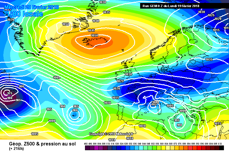
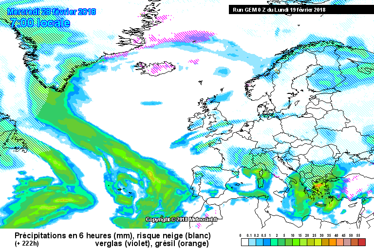
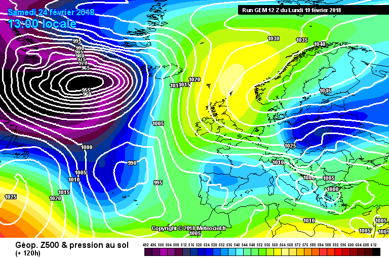
intanto gem spettacolo, nevone fotonico.
Re: irruzione gelida di fine febbraio 2018 mappe commenti
Inviato: lun feb 19, 2018 4:25 pm
da Elia
intanto gem spettacolo, nevone fotonico.
[/quote]
oro
Re: irruzione gelida di fine febbraio 2018 mappe commenti
Inviato: lun feb 19, 2018 4:27 pm
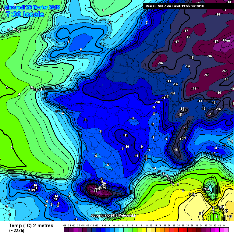
da Stormsnow
termiche previste al suolo
Re: irruzione gelida di fine febbraio 2018 mappe commenti
Inviato: lun feb 19, 2018 4:31 pm
da Stormsnow
Ulambataro ha scritto: ↑lun feb 19, 2018 4:28 pm
fino a giovedì nulla di certo

questo sicuro infatti attendiamo, comunque vada irruzione spettacolare.
Re: irruzione gelida di fine febbraio 2018 mappe commenti
Inviato: lun feb 19, 2018 4:59 pm
da lupacchiottoirpino
Intanto anche gem rialza il tutto, ma porca vacca
Re: irruzione gelida di fine febbraio 2018 mappe commenti
Inviato: lun feb 19, 2018 5:00 pm
da lupacchiottoirpino
Re: irruzione gelida di fine febbraio 2018 mappe commenti
Inviato: lun feb 19, 2018 5:02 pm
da TURCHIA
aggiornamenti ECMWF stasera Turchia determineranno il destino del mio consiglio in alto a freddo AO-nao-PN, o uno sguardo e ti ricordi sempre negativo NAO in SYSTEMS LEGENDARY TURCHIA RICEVE
Re: irruzione gelida di fine febbraio 2018 mappe commenti
Inviato: lun feb 19, 2018 5:04 pm
da Stormsnow
gfs a 108h lo abbassa
Re: irruzione gelida di fine febbraio 2018 mappe commenti
Inviato: lun feb 19, 2018 5:06 pm
da TURCHIA
Jet akımları Türkiye yönünde TURKİSH
Re: irruzione gelida di fine febbraio 2018 mappe commenti
Inviato: lun feb 19, 2018 5:08 pm
da Stormsnow