Estofex nord est spazzato via
Inviato: sab lug 06, 2019 7:57 am
http://www.estofex.org/
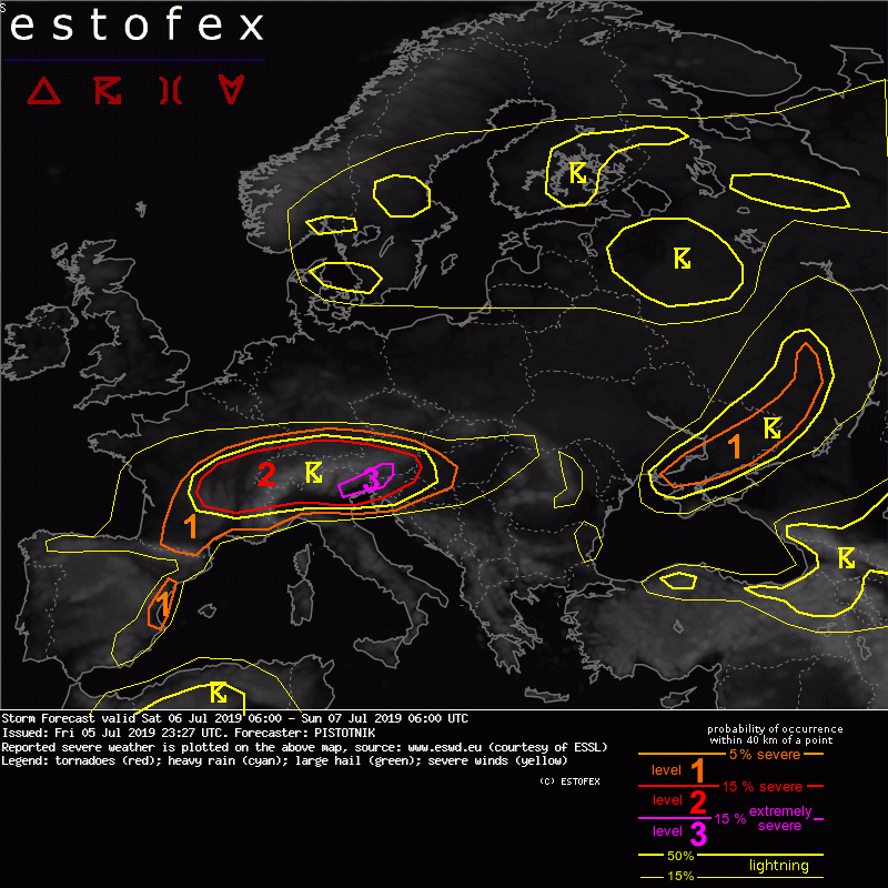
The risk of extreme developments culminates on the southern side of the Alps in the late afternoon and evening. From 14 UTC onwards, storms from the southern Alps will likely start to descend into the Klagenfurt Basin (S Austria) and the plains of Friuli and Veneto (NE Italy), where they encounter the highest CAPE and the best wind profiles on the moist side of a dryline. Fine-meshed models agree on several right-moving supercells which can bring large to giant hail, downbursts and very heavy rain. In addition, a remarkable tornado risk unfolds in the NE Italian plains, where sea breezes enhance low-level shear and may boost 2m dewpoints to 24 or 25C by sunset. A few tornadoes are possible and even a strong tornado is not ruled out in case the track of a supercell can connect with an outflow boundary, the sea breeze front or another convergence zone.
The risk of extreme developments culminates on the southern side of the Alps in the late afternoon and evening. From 14 UTC onwards, storms from the southern Alps will likely start to descend into the Klagenfurt Basin (S Austria) and the plains of Friuli and Veneto (NE Italy), where they encounter the highest CAPE and the best wind profiles on the moist side of a dryline. Fine-meshed models agree on several right-moving supercells which can bring large to giant hail, downbursts and very heavy rain. In addition, a remarkable tornado risk unfolds in the NE Italian plains, where sea breezes enhance low-level shear and may boost 2m dewpoints to 24 or 25C by sunset. A few tornadoes are possible and even a strong tornado is not ruled out in case the track of a supercell can connect with an outflow boundary, the sea breeze front or another convergence zone.