A level 1 and level 2 are issued for N Italy, S Switzerland, S Austria and Slovenia for large hail, flash floods and to a lesser degree severe convective wind gusts, in NE Italy also for tornadoes.
Estofex grandine epocale e tornadoes al nord
Moderatori: lupacchiottoirpino, JamesNeve, Gianlucameteo
-
Davide
- Site Admin
- Messaggi: 8894
- Iscritto il: sab dic 30, 2017 9:33 am
- OCCUPAZIONE: Sommo
- Località: Rijeka Hrvatska na moru
Estofex grandine epocale e tornadoes al nord
A level 1 and level 2 are issued for N Italy, S Switzerland, S Austria and Slovenia for large hail, flash floods and to a lesser degree severe convective wind gusts, in NE Italy also for tornadoes.
Rijeka Hrvatska sul mare vita
-
franco feltre
- Messaggi: 87754
- Iscritto il: dom dic 31, 2017 12:15 pm
- OCCUPAZIONE:
Re: Estofex grandine epocale e tornadoes al nord
peso che stavolta ci azzecchino , stare molto attenti .DavideBassano ha scritto: ↑ven lug 20, 2018 2:45 pm
A level 1 and level 2 are issued for N Italy, S Switzerland, S Austria and Slovenia for large hail, flash floods and to a lesser degree severe convective wind gusts, in NE Italy also for tornadoes.
-
MarcoSarto
- Messaggi: 1877
- Iscritto il: sab dic 30, 2017 9:12 pm
- OCCUPAZIONE:
- Località: Alto Varesotto 215 mt
Re: Estofex grandine epocale e tornadoes al nord
The most robust severe weather threat evolves in the warm air advection regime on the southern side of the Alps.
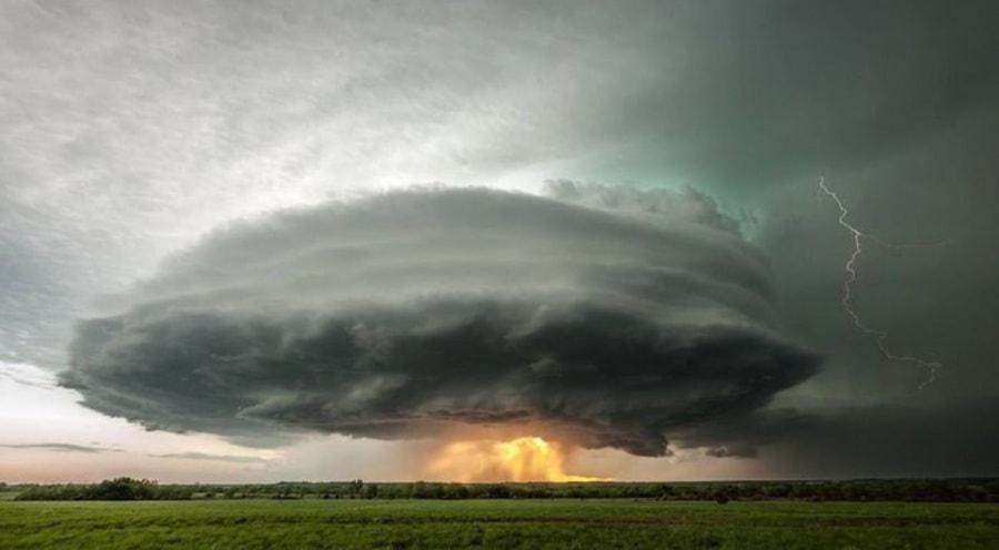
A first vorticity maximum will facilitate numerous storms over the mountains of NE Italy and S Austria from the early afternoon onwards. As soon as they detach from the mountains and tap into the thermal upvalley flow regime, they will encounter plentiful CAPE (around 1000 J/kg in S Austria and Slovenia, up to 2500 J/kg in N Italy) and increasing 0-6 km shear (around 15 m/s with slightly veering profiles). An organization into multi- or supercells is expected. The main risks are large hail (possibly approaching 5 cm in case of supercells) and flash floods, as the wind profiles and the orographic forcing will favor side- and backbuilding. The risk of a few severe downbursts increases as well in case of upscale growth. It is likely that an MCS with an ongoing severe weather risk will move from S Austria into Slovenia before it gradually decays in the evening.
Secondary storms may initiate along outflow boundaries in the NE Italian forelands, where a CAPE maximum and enhanced low-level shear are expected in the sea breeze regime. Some convection-resolving models showed a dangerous scenario with strongly right-moving supercells zipping along the sea breeze front, which would enhance the tornado chances considerably next to the mentioned other risks. A level 3 was considered for this area, but was discarded due to the lack of steeper lapse rates, which would favor more extreme hail and wind events, and due to the possibility that the capping inversion will hold.
Convective initiation will be more sluggish in NW Italy, but a second round of storms will probably detach from the western Alps by evening and travel eastward across Piedmonte and Lombardia after nightfall. The arrival of the main trough axis will likely keep at least scattered convection going through the night, possibly including one or two large clusters. Flash floods become a distinct possibility, especially in the Swiss Ticino and neighboring parts of Italy which may be exposed to intense storms for several hours. Discrete or tail-end storms may still be highly organized and pose additional risks of large hail and severe wind gusts under further increasing 0-6 km shear up to 20 m/s, if they manage to stay surface-based. The severe weather situation extends into Saturday.
Avatar --> 05/03/2016
-
Davide
- Site Admin
- Messaggi: 8894
- Iscritto il: sab dic 30, 2017 9:33 am
- OCCUPAZIONE: Sommo
- Località: Rijeka Hrvatska na moru
Re: Estofex grandine epocale e tornadoes al nord
Intanto nubifragio ed alcuni chicchi come noci
Rijeka Hrvatska sul mare vita
-
marcolino977

- Messaggi: 414
- Iscritto il: mar gen 02, 2018 6:14 pm
- OCCUPAZIONE:
- Località: Gaggio di Marcon(VE) 5 m s.l.m
Re: Estofex grandine epocale e tornadoes al nord
domani giornata top
-
MINGOLINO

- Messaggi: 1324
- Iscritto il: dom dic 31, 2017 7:13 am
- OCCUPAZIONE:
- Località: RAVENNATE NORD DOCG-O BOLOGNA
Re: Estofex grandine epocale e tornadoes al nord
Qua flop orto intatto
Ravennate nord docg

Re: Estofex grandine epocale e tornadoes al nord
Anche da me flop totale. Orto totalmente integro.
Aspettando la dama che non verrà perché il FNM prevarrà. Cit. enrico86
La democrazia muore sul mio confine. cit.Mingolino
-
marcolino977
- Messaggi: 414
- Iscritto il: mar gen 02, 2018 6:14 pm
- OCCUPAZIONE:
- Località: Gaggio di Marcon(VE) 5 m s.l.m
Re: Estofex grandine epocale e tornadoes al nord
bel temporalone senza danni,ottimo così
Re: Estofex grandine epocale e tornadoes al nord
Haia!!!
Aspettando la dama che non verrà perché il FNM prevarrà. Cit. enrico86
La democrazia muore sul mio confine. cit.Mingolino
Re: Estofex grandine epocale e tornadoes al nord
Altro nubifragio in corso su Rimini! Venite tutti, a breve la bozza finisce.
Aspettando la dama che non verrà perché il FNM prevarrà. Cit. enrico86
La democrazia muore sul mio confine. cit.Mingolino